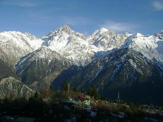
LADAKH is a mysterious land shrouded in myth and legend. Much of its ancient history is known only through the mythology of its people as its written history is of very recent origin. Known for centuries as the 'land of passes' (La-pass;Dakh-land), Ladakh was described by Fa-hian, who travelled across its inhospitable terrain in 399 A.D., as 'The land where snow never melts and only corn ripens'.
Its landscapes are forbidding by any measure. Snow-swathed mountains rise to several thousand feet above one of the most elevated plateux on earth. A treeless wind-swept country, much of Ladakh can be termed as mountains, Arctic desert, where everything is parched bt the rarefied dryness of the atmosphere. Scattered here and there, a few narrow fertile valleys provide a stark contrast to an otherwise barren, beautiful country of intense sunlight and clear sparkling air.
Major Tourist Destinations LADAKH is situated between 30 degree to 36 degree east latitude and 76 degree to 79 degree north longitude. The region of Ladakh spread over to an area of 96,701 Sq. Kms and comprising a population of 2 Lakhs habitants and consists of two districts, Leh and Kargil. The region of Ladakh normally remains land locked between November to June every year as Srinagar-Ladakh and Ladakh- Monali highways,which connect Ladakh with the other parts of the country, remain closed during this period because of snow and rigorous winter.Ladakh is also the land of many lakes and springs. Among the springs, the famous are the sulphar springs of Panamic (Nobra), Chumathang and Puga of Changthang, which are famous for early curing of joints/rheumatic diseases. Many mineral springs are also found in some remote parts of Ladakh. People of region use the spring water as medicine to prevent and cure themselves from many diseases. The important lakes which fall within the jurisdiction of Ladakh are Pangong Lake (150 Kms. long, 4 Kms. wide situated at a height of 14,000 ft.).

Places to See-
You will find couple of places left on the planet like Ladakh. It is based on the truly amazing Himalayan rain shadow, so receives no monsoon throughout the summer time, but hefty snowfall throughout its lengthy (November – Late May) winter. In summer time it's a high, arid fortress encircled by huge peaks and trisected through the quick, snow – laden Indus and Zanskar rivers.
The landscape resembles those of neighbouring Tibet (El born area may also be known as “ Little Libetâ€) , along with the look of the folks, their religion – devoutly Buddhist – and also the magnificent monasteries perched imperiously on granite crags and steep slopes.
Trekking in Ladakh is really as unique because the land itself. Leh, the divisional headquarters, is obtainable from Srinagar, Delhi and Chandigarh by air and bus. Ladakh may be the land of impossible mountain tops and engaging monasteries. It depends on the tri- junction from the historic ‘ Silk Route’ from Sinkiang to West Asia and also to the flatlands the indian subcontinent. You will find numerous interesting places and monasteries to go to around Leh. A few of the important places are: Leh Structure, the monasteries of Shey, Hemis, Alchi, Thikse and Lamayuru. Markha Valley trek over Gongmaru La and Gandha La is easily the most adventurous. Another trekking trail leads southwards from Alchi and after crossing Stapski La, removes and reaches Nimu. Another trail towards north of Leh increases over Khardung La and reaches the Nubra Valley.
Indus Valley
In an average elevation of 3500 m is sand-witched between your Zanskar Range on its South and also the Ladakh Range on its North, This is actually the physical backbone, and also the historic heartland of Ladakh. All major sites associated with its dynastic history are here, beginning with Leh, the main city city. The majority of the populace resides across the Indus. Its primary attraction would be the numerous Buddhist monasteries, quaint towns, festivals, festivals and bazars. Air and road communications converage at Leh.
Zanskar Valley
Certainly one of Ladakh’s remotest regions. A 300 km lengthy valley ringed by mountain tops, purely available by high passes. The Valley of Zanskar can be found within the inner Himalaya and it is greater than most regions of Ladakh. The weather is extremely Harsh and receives hardly any rain. The twin peaks of Nun-Kun, its Monasteries and it is very rugged, awe-ambitious landscape are its primary points of interest.
Shyok Valley
The Shyok River receives the waters from the Nubra and Changchenmo rivers. It increases in the Khumdang glacier, which may be contacted from Shyok. The Shyok River requires a southerly course after it's became a member of through the Nubra River. After that the Shyok flows in to the Indus at Keris.
The stream freezes in the winter months, thus developing a simple access between your Khaplu and also the Nubra valleys. In summer time, because the snow touches within the uplands, the stream overflows its banks and inundates the nearby plain for a lot of kilometers, sometimes developing a huge marsh. Throughout this era, the Shyok River needs to be entered on rafts of inflated skin.
Padum Valley
Padum the main city from the ancient kingdom of Zanskar, Padum (3505 m) is present administrative headquarters from the region. Having a population of nearly 1500, Padum could be referred to because the most populous settlement of Zanskar, otherwise a really scarcely lived on valley. Incidentally, it is just in Padum that there's a residential area of Muslims making up up to 50 % the township's population, its origin in the region dating from mid 17th century. Recently, Padum has turned into a famous like a major trekking base along with a popular tourist destination. Several places of tourist interest near the township could be visited throughout entertaining walks. The closest monument is some ancient rock carving on the huge boulder close to the river bank, just beneath that old township. These dates in the eighth century and supply epigraphic evidence the region was intoxicated by North Indian Buddhism since ancient occasions. The Starrimo monastery about 30 resident monks clings to some tree-covered ridge over the old town. Over the expanse of cultivation lies that old village of Pibiting, centered by its attractive hilltop monastery, an excellent symbol of stupa architecture.
Zangla Valley
Laying deep within the northern arm of Zanskar in the finish from the 35 km. Lengthy rough road from Padum, Zangla had been ruled with a titular king till his dying a couple of in the past. That old castle now in ruins except from the small chappel, occupies a hill, looking over the desertic valley below. Nearby may be the old Nunnery worth a trip for that austere existence type of the little monastic community of nuns. A classic monastery located in the encompassing village of Tsa-zar has exquisite frescos that needs to be skipped. The village lies mid-way between Stongdey and Zangla. Zangla may be the nodal point around the popular Padum-Strongdey-Zangla-Karsha-Padum round trip, which provides coverage for the majority of the cultural sites of Zanskar. That old rope suspension bridge spanning the tumultuous Zanskar near Zangla- an uncommon task of folk engineering - isn't any more being used, but nonetheless visible. The stream has become entered with a temporary footbridge for approaching the left bank along that the trail to Karsha follows. Zangla can also be the take-off point for that Padum-Markha valley treks.
Rangdum Valley
The farthest and also the most isolated area of the Suru Valley, Rangdum is definitely an elliptical broadened plateau encircled by colourful hillsides around the one for reds and glacier encrusted rocky mountain tops alternatively. Situated 130 kms South- east of Kargil, it falls half way between Kargil and Padum. Because of its seclusion from lived on parts either of Suru or Zanskar, areas wild beauty is nearly haunting, while its isolation is near perfect even while the unpaved Zanskar road traverses its length. The main attraction of the area is definitely an imposing 1700s Buddhist monastery about 40 monks in residence. Perched picturesquely atop a centrally rising hillock that is established around through the bifurcated span of an outrageous mountain stream, the Rangdum monastery has got the aura of the ancient fortification protecting a mystical mountain valley. The villagers are descendents from the monastery's farming, serf-tenants, who don't own any land in the area. The monastery likes perpetual and unalienable possession from the entire valley such as the fields tilled through the villagers, the pastures, hillsides as well as the streams. Rangdum also can serve as an essential trekking base. Typically the most popular trek came from here results in Henaskut near Lamayuru, over the spectacular gorge from the kanji valley. This 5-day trek also forms the final leg of these two week lengthy trans-Himalayan traverse between Kashmir and Ladakh.
Phugthal Valley
The Phugthal complex spills from the mouth of the huge cave up high within the sheer mountain face of the lateral gorge by which a significant tributary from the southern Lungnak (Lingti-Tsarap) River flows. Possibly, probably the most isolated monastic establishment of Zanskar, its foundation go as far back towards the early twelfth century a minumum of one old chappel, one of the several a number of so it consists, has frescos and ceiling adornments reflecting strong Indian artistic and iconographic influence. Phugthal is obtainable in the Padum-Manali trekking route via a 7 km lengthy trail that branches removed from the Purney Bridge around the primary trail. A trip to Phugthal, including Bardan and Muney monasteries enroute, constitutes a good 5-days round trek from Padum. Alternatively, it's possible to add one extra day to Padum-Manali trekking itinerary to incorporate each day-return trip to this excellent monastic establishment lived on with a resident community around 40 monks.
Stongdey Valley
The monastery of Stongdey lies 18 kms. To northern Padum, on the highway resulting in Zangla. A classic foundation connected using the Tibetan Yogi, Marpa, Stongdey has become the 2nd biggest monastic establishment of Zanskar, lived on through the resident community around 60 Gelukpa monks. The sprawling whitewashed complex has numerous temples, each a repository from the region's wealthy monastic legacy. Stongdey could be arrived at by feet within 4 hrs across the lately laid rough road. The ascend towards the monastery is quite strenuous, but it's worthwhile for that breathtaking scenery from the valley offered by here.
Sankoo Valley
A attractive expanse encircled by colorful rocky mountain tops, Sankoo is definitely an approaching township having a small bazaar (42 kms south of Kargil) and various towns around Dense farms of poplars, willows, myricarea and wild roses fill the bowl formed valley, passing on the atmosphere of the guy-made forest hidden inside the mountain ramparts. Two side valleys drained by large tributary streams from the Suru river, the Kartse flowing in the east and also the Nakpochu climbing down in the west, open on each side from the expanse. The Karste Valley runs deep in to the eastern mountain tops mass with a lot of isolated towns hidden within its course. Some-day trek between Sankoo and Mulbek follows this valley the path passes through some very beautiful all downhill areas in route the 4950 m high Rusi-la . Our prime altitude settlement of Safi and it is mixed Buddhist-Muslim human population is struck between your Rusi-la and also the Shafi-la that the ultimate leg from the trek passes before entering the Mulbek valley. A southward diversion in the feet from the Rusi-la results in Rangdum over the glaciated Rangdum pass in which the Karste River increases. The Three-day trek to Drass over the Umba-la (3350 m) follows the western valley. Sankoo is an extremely well-liked by local have a picnic enthusiasts who throng the region from Kargil town along with other places. In your area it's also common as a location of pilgrimage towards the ancient shrines of Muslin scholar-saint, Sayed Mir Hashim, who had been specifically asked from Kashmir for providing religious teachings towards the region's Buddhist ruler, Thi-Namgyal from the Suru principality, following his conversion to Islam throughout the 16th century. The shrine can be found within the village of Karpo-Khar around the borders of Sankoo in which the chief had his summer time structure.
Drass Valley
Drass (3230 m), 60 km west of Kargil on the path to Srinagar, is really a small township laying within the center from the valley of the identical title. It is famous because the second very coldest lived on place on the planet due to the brilliant cold that descends upon the valley together with repeated snowfalls throughout winters. Winter temperatures are commonly known as to plummet to under minus 40 levels.
The Drass valley begins from the bottom of the Zojila pass, the Himalayan gateway to Ladakh. For hundreds of years its occupants are recognized to have discussed this formidable pass even throughout probably the most dangerous period within the late fall or springtime, once the whole sector remains snow-bound and it is susceptible to frequent snow storms, to move trader's merchandise across and also to help stranded vacationers to traverse it. Due to their mastery within the pass they'd established a monopoly within the transporting trade throughout the heydays from the Pan-Asian trade. A hardly people long lasting with fortitude and severity of the valley's winter, the occupants of drass can very well be referred to because the guardian's of Ladakh's gateway.
Suru Valley
Probably the most beautiful parts of Ladakh , the Suru Valley forms the mainstay of Kargil district. Laying situated across the north-eastern foothills from the great Himalayan Wall, it stretches from Kargil town, first southward for any period of about 75 Kms Up to the expanse around Panikhar, thence eastward for an additional stretch of nearly 65 kms up to the feet from the Penzila watershed in which the Suru valley increases. Its composite population around 30,000 -- mainly of Tibeti-Darad descent -- are Muslims who had converted their Buddhist belief around the center of the 16th century. Top of the valley reaches from the valley, particularly round the Sankoo bowl, the Panikhar expense and also the greater stretch beyond, present a spectacle of breathtaking features-regal mountain ramparts crowned by snow assigned peaks, undulating all downhill slopes draining into wild mountain streams of foaming cascades of pristine water, awesome glaciers climbing down across the Himalayan slopes towards the river mattress in riverine formation, Quaint towns of adobe houses straggling dry hillocks encircled by large areas of lush crops downward the patches of all downhill pastures uphill. The good thing about this region is further enhanced through the sheer contrast supplied by the towering peaks of Kun (7035 m) and Nun (7135 m) which loom within the skyline within their crystalline majesty.